
Earth’s Largest Solar Mirror
Salar de Uyuni, Planetary Sunglint, Satellite Calibration, and the Ancient Tiwanaku Context

Earth’s Largest Solar Mirror
Salar de Uyuni, Planetary Sunglint, Satellite Calibration, and the Ancient Tiwanaku Context
Author: oDinZu C. WenKi with Astraea
Document version: v1.1
Date: May 6, 2026
Category: Earth Optics, Satellite Calibration, Altiplano Archaeology, and Cultural Landscape Studies
Abstract
The largest reflection of sunlight on Earth depends on the meaning of the word largest. If largest refers to a coherent land-based natural mirror, Salar de Uyuni in Bolivia is the strongest candidate: a salt flat covering about 10,582 square kilometers, whose rainy-season water layer creates a vast, sky-reflecting surface. If largest refers to the broadest dynamic reflection visible from orbit, oceanic sunglint is larger because the oceans provide a planetary reflective field whenever solar angle, surface smoothness, and observer geometry align. This journal distinguishes the localized mirror system of Salar de Uyuni from the planetary sunglint field of the ocean and focuses on an additional scientific role: satellite technology calibration. Salar de Uyuni is not only a natural wonder. Its flatness, reflectance, high elevation, seasonal specularity, and broad uniformity have made it a natural calibration plane for Earth-observing satellites, including laser altimetry, radar altimetry, and optical remote sensing workflows. The journal further adds the ancient Tiwanaku context of the Bolivian Altiplano, emphasizing that the region has long joined sunlight, water, stone, orientation, agriculture, and measurement into human knowledge systems. Recent Sentinel-3 research refines the modern scientific picture by showing that the wet Salar is not a uniform mirror at all phases and places, but a changing surface whose specular properties reveal water depth, wind state, roughness, and hydrological phase.
Keywords: Salar de Uyuni; sunglint; satellite calibration; radar altimetry; laser altimetry; ICESat; Envisat; CryoSat; Sentinel-3; albedo; specular reflection; Tiwanaku; Altiplano; Aymara; Earth observation
1. Introduction
Sunlight becomes scientifically useful when it meets a surface whose geometry is known. Across Earth, light is absorbed by soils and vegetation, scattered by clouds and aerosols, diffused by rough terrain, and reflected by water, ice, salt, and snow. In the strongest mirror-like cases, reflected sunlight exposes a precise relationship among the Sun, the surface, and the observer. This relationship is central to both visual beauty and remote sensing science.
The question, “What is the largest reflection of sunlight on the planet?” has two technically valid answers. In ordinary visual language, the answer is Salar de Uyuni, the Bolivian salt flat that becomes a huge natural mirror after rainfall. In planetary optical language, the answer is oceanic sunglint, a moving specular reflection field produced when sunlight reflects from water surfaces directly into a satellite sensor, astronaut camera, or aircraft observer.
This journal resolves the apparent ambiguity by separating two categories: the largest localized natural mirror and the largest dynamic planetary reflection field. It then develops the scientific meaning of Salar de Uyuni as a natural calibration surface for satellite technology and places the Salar inside the broader cultural and archaeological landscape of the Bolivian Altiplano, including the ancient Tiwanaku polity. The central claim is simple: the same highland region that gives Earth a natural solar mirror also preserves deep histories of human orientation to sunlight, water, stone, agriculture, and measurement.
2. Definitions and Scope
A reflection of sunlight may be described by area, coherence, brightness, wavelength, and observer geometry. Area describes the physical extent of the reflecting surface. Coherence describes how smoothly and directionally the surface reflects light. Brightness describes how much radiation returns toward the observer or sensor. Wavelength matters because a surface smooth at visible wavelengths may behave differently at radar wavelengths. Observer geometry matters because specular reflection depends on the angle among the Sun, the surface, and the instrument.
In this paper, “localized natural mirror” means a bounded natural land surface that visually behaves like a mirror under favorable environmental conditions. By this definition, Salar de Uyuni is the main subject. “Planetary reflection field” means a large, dynamic, angle-dependent reflection from oceans or other water bodies, especially as viewed from orbit. By this definition, oceanic sunglint is larger and more common than the Salar mirror effect, but it is not fixed to one place.
The distinction matters because casual statements such as “the world’s largest mirror” may be visually true and scientifically incomplete at the same time. Salar de Uyuni deserves that name as a coherent land-based mirror. The ocean deserves recognition as the larger planetary-scale reflective system.
3. Geographic and Surface Character of Salar de Uyuni
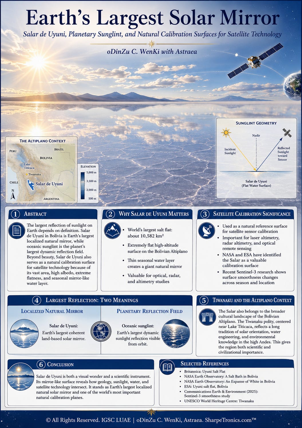
Salar de Uyuni lies on the Bolivian Altiplano in southwestern Bolivia, near the crest of the Andes. Encyclopaedia Britannica identifies it as Bolivia’s largest salt-encrusted waste area and gives its area as about 4,085 square miles, or 10,582 square kilometers, at an elevation of about 3,656 meters above sea level [1]. Wikipedia gives the same approximate area and identifies it as the largest salt flat in the world [2].
The Salar’s mirror behavior depends on three linked properties. First, the salt flat is extremely broad. Second, it is unusually flat, with very little topographic variation across its basin. Third, seasonal rainwater may form a thin, calm water layer over the salt crust rather than immediately draining away. NASA notes that during the rainy season, water may fill part of the salt flat and give it a stunning mirror-like appearance [3].
The salt crust often appears as a vast white plane during dry phases. During wet phases, the surface may become a shallow water sheet, reflecting sky, clouds, stars, and the Sun. The wet Salar is therefore not a conventional lake, not a normal desert, and not merely a high-albedo salt crust. It is a phase-changing optical surface: dry, it behaves more like a bright diffuse reflector; wet and calm, it behaves more like a specular mirror.
4. Optical Physics: Albedo, Specular Reflection, and Sunglint
Two optical concepts organize the analysis: albedo and specular reflection. Albedo is the fraction of incoming radiation reflected by a surface. Salt, snow, ice, and clouds often present high albedo because they return a larger fraction of sunlight than darker surfaces. PubMed’s record of a UV-radiation campaign at Salar de Uyuni reports erythemally effective UV albedo of 0.69 plus or minus 0.02, showing that the salt-flat environment is strongly reflective in the measured ultraviolet context [4].
Specular reflection is mirror-like reflection. Instead of scattering radiation broadly in many directions, a smooth surface reflects incoming light into a preferred outgoing direction. In visible-light terms, the wet Salar becomes memorable because shallow water creates a smooth reflective interface. In orbital remote-sensing terms, the same principle produces sunglint: a mirror-like reflection of sunlight from water back toward a satellite sensor or astronaut.
NASA Earth Observatory describes sunglint as a mirror-like specular reflection of sunlight off water and back toward the satellite sensor or astronaut [5]. NASA also explains that smoother water reflects more sunlight directly back to a satellite imager, while rougher water scatters light in more directions and appears darker [6]. This is the same basic geometry behind the Salar’s visual mirror state, but applied to much larger water surfaces such as oceans, bays, lakes, and rivers.
5. Salar de Uyuni as Earth’s Largest Localized Solar Mirror
The Salar’s title as Earth’s largest localized natural mirror rests on its combination of area, flatness, water behavior, and visual coherence. A wet mirror surface need not cover the entire 10,582 square kilometers at every moment. Rainfall, evaporation, wind, water depth, and basin microtopography determine how much of the salt flat behaves specularly. However, when large portions of the Salar are wet and calm, the mirror effect becomes geographically immense.
This is why the Salar occupies a unique category. Snowfields may reflect strongly, but they scatter diffusely. Ice sheets are huge, but they are usually rough, crevassed, or optically complex at human scales. Oceans are far larger, but their mirror-like sunglint patch moves with geometry and wave state. Salar de Uyuni combines a defined land boundary with a temporary water film over an exceptionally flat salt crust, producing the celebrated sky-ground continuity that visitors and satellite images both reveal.
The most accurate statement is therefore not simply that Salar de Uyuni is the largest reflection of sunlight on Earth. A more precise conclusion is that Salar de Uyuni is Earth’s largest localized natural solar mirror, while the oceans produce Earth’s largest dynamic sunglint reflection field.
6. Satellite Technology Calibration: Why the Salar Matters
Satellite instruments require calibration because orbital measurements must be checked against known references. A satellite may measure height, reflectance, surface roughness, brightness temperature, or radar return strength, but the instrument still needs stable targets to verify that the measurement is accurate. Calibration surfaces reduce uncertainty by offering known or repeatable surface conditions.
An effective natural calibration surface should be broad enough to fill an instrument footprint, bright enough to provide strong return signals, stable enough for repeated observations, and uniform enough to limit noise from terrain variation. Salar de Uyuni satisfies these conditions better than most landscapes. NASA states that the Salar’s unusually flat surface has served as an ideal location for testing newly launched satellite sensors, and that scientists working with both ICESat and Envisat have used Salar de Uyuni to calibrate onboard sensors [7]. NASA further states that salt flats make ideal calibration locations because they are large, stable surfaces with strong reflection, similar in some ways to ice sheets [7].
The calibration value is not only optical. ESA states that, overall, Salar de Uyuni has surface elevation variation of less than 1 meter, making it ideal for calibrating satellite radar altimeters, which measure surface topography [8]. This means the Salar functions as a natural reference plane across multiple measurement regimes. It is a visual mirror, a high-albedo optical target, a radar-altimetry reference surface, and a laser-altimetry validation field.
7. Laser Altimetry, GPS Ground Truth, and the ICESat Correction
Laser altimetry measures height by emitting laser pulses toward Earth and measuring the return path. For satellite laser altimetry, a broad and flat terrestrial target is valuable because small differences between expected and measured elevation reveal instrument bias, pointing error, timing error, and processing uncertainty.
The early ICESat/GLAS era is central to the Salar’s calibration history. NASA’s ICESat history page records that ICESat launched on January 12, 2003 from Vandenberg Air Force Base, California, while NASA’s Earthdata instrument page identifies GLAS as the Geoscience Laser Altimeter System aboard ICESat [9]. NASA’s Technical Reports Server describes work using ICESat, GPS, and MISR to measure salt-surface topography at Salar de Uyuni, calling it the largest salt flat on Earth in that report and noting less than 40 centimeters of relief except for a few bedrock islands [10].
A correction is needed when reading the Wikipedia satellite-calibration section. The page currently says that NASA’s ICESat-2 mission conducted extensive GPS surveys over the Salar in September 2002 [2]. That phrasing is temporally inconsistent. NASA lists ICESat-2’s launch date as September 15, 2018 [11]. The September 2002 GPS survey belongs to the pre-launch ground-truth and calibration lineage for the original ICESat/GLAS mission, not ICESat-2. The deeper point remains valid: the Salar’s flatness supported satellite altimetry calibration. The mission label should be handled carefully in academic writing.
8. Radar Altimetry: Envisat, CryoSat, Sentinel-3, and Sentinel-3B
Radar altimeters measure surface topography by transmitting microwave pulses downward and analyzing the echo returned from Earth. Over the ocean, radar altimetry supports sea-level science. Over ice sheets, it supports cryosphere monitoring. Over a surface such as Salar de Uyuni, it supports calibration and validation because the expected return comes from a broad, flat, reflective target.
ESA specifically links Salar de Uyuni to radar-altimeter calibration and notes that CryoSat and Copernicus Sentinel-3 satellites carry radar altimeters [8]. NASA’s Earth Observatory also identifies Envisat as one of the missions whose scientists took advantage of Salar de Uyuni to calibrate sensors [7]. These mission references show that the Salar’s scientific value crosses institutional boundaries: NASA, ESA, and Copernicus-era missions all benefit from known natural reference surfaces.
The wet Salar’s radar behavior is especially important because radar does not “see” the surface in the same way the human eye does. A surface that looks smooth at visible wavelengths may not be uniformly smooth at Ku-band radar wavelengths. Therefore, the Salar is scientifically valuable not because it is a perfect mirror in every circumstance, but because its departures from perfect smoothness are measurable and meaningful.
9. Recent Sentinel-3 Evidence: A Mirror That Changes
A 2025 paper in Communications Earth & Environment used approximately 392,000 radar-altimeter bursts from the Sentinel-3A and Sentinel-3B constellation, collected along six ground tracks from 2016 onward, to study the spatial and temporal evolution of wet-surface smoothness in Salar de Uyuni [12]. This work reframes the Salar from a static mirror into a dynamic hydrological and electromagnetic surface.
The study reports that rainfall mainly occurs during the wet season from December to March, that the Salar is a closed plateau with minimal topographic variation typically within 1 meter, and that rainfall water accumulates because the impermeable bed provides negligible drainage [12]. During field work, optical measurements found zero vertical surface displacement within plus or minus 0.5 millimeters at a water depth of 1.8 centimeters [12]. For radar altimetry, this level of smoothness matters because a calm water layer may produce extremely strong specular radar returns.
The same study reports measured radar cross-section values of about 120 plus or minus 0.3 dBsm over 100 kilometers along a Sentinel-3 track near the in situ site, closely matching the theoretical maximum expected for specular bursts over the Salar [12]. It also reports two statistical radar-return populations, one associated with nonspecular or less specular conditions and another near 119.5 dBsm associated with wet, wind-undisturbed specular surfaces [12].
The most important conclusion is a limitation: the Salar is not always a vast uniform mirror for radar altimetry. Its smoothness evolves across space and phase. Water coverage, wind, evaporation, salt-crust texture, rainfall timing, and basin location all matter. This does not weaken the Salar’s importance. It makes the Salar more scientifically valuable because satellite technology is able to observe the transformation from dry crust to smooth water mirror and then back toward drying, quasi-specular states.
10. Sunglint and the Larger Planetary Reflection Field
While Salar de Uyuni is the largest localized land mirror, oceanic sunglint is the larger planetary reflection phenomenon. Sunglint appears when sunlight reflects from water at the same angle that a satellite or astronaut views the surface. NASA describes this as an optical phenomenon that creates mirror-like specular reflection back toward the observer [5].
The ocean’s reflective area is vastly larger than any salt flat. However, sunglint is not a fixed object. It is a moving alignment among Sun, water surface, and observer. A satellite may see a bright silver band over the Atlantic in one pass and no similar highlight in a different geometry. Smooth water produces stronger glint, while rough water scatters light and darkens the reflection [6].
This explains the two-answer structure of the original question. The largest stable, named, land-based solar mirror is Salar de Uyuni. The largest dynamic reflection field is oceanic sunglint. The two belong to the same optical family but differ in boundary, duration, and measurement use.
11. Comparative Typology of Earth’s Major Solar Reflectors
The following table summarizes the difference between major sunlight-reflecting surfaces. The comparison shows why Salar de Uyuni occupies a rare position between ordinary high-albedo terrain and planetary-scale sunglint.
Table 1. Comparative reflection and measurement types across natural surfaces and cultural landscapes.
Surface type:
Salar de Uyuni, dry salt crust
Dominant reflection mode:
High-albedo diffuse reflection with radar-relevant crust response
Scale:
Localized, about 10,582 square kilometers
Stability:
Seasonally stable, but surface texture varies
Scientific use:
Optical and radar calibration target
Surface type:
Salar de Uyuni, wet phase
Dominant reflection mode:
Specular mirror-like reflection from shallow water
Scale:
Localized but very broad during extensive flooding
Stability:
Short-lived, wind- and evaporation-sensitive
Scientific use:
Radar-altimeter smoothness studies and optical mirror observations
Surface type:
Open ocean sunglint
Dominant reflection mode:
Dynamic specular reflection from water
Scale:
Planetary-scale, moving with geometry
Stability:
Variable with waves, wind, current, and viewing angle
Scientific use:
Ocean-surface roughness, oil slick detection, atmospheric and ocean-feature visualization
Surface type:
Snow and ice fields
Dominant reflection mode:
High albedo, mixed diffuse and directional behavior
Scale:
Regional to continental
Stability:
Seasonal to multi-year depending on location
Scientific use:
Climate, cryosphere, and albedo studies
Surface type:
Cloud decks
Dominant reflection mode:
High albedo scattering
Scale:
Regional to planetary
Stability:
Rapidly changing
Scientific use:
Radiation budget, weather, and climate monitoring
Surface type:
Tiwanaku highland landscape
Dominant reflection mode:
Solar orientation, water management, agricultural reflection of environmental cycles
Scale:
Regional Altiplano cultural landscape
Stability:
Archaeological and living cultural continuity
Scientific use:
Context for ancient measurement, orientation, and highland adaptation
12. The Salar as a Planetary Calibration Instrument
The phrase “natural calibration instrument” is not metaphorical exaggeration. The Salar provides a known surface against which orbital sensors are tested. Its role resembles a planetary-scale laboratory bench: the satellite is the measuring device, the Sun or radar transmitter provides illumination, the Salar provides the reference plane, and the returned signal reveals instrument behavior.
This role becomes especially clear in radar altimetry. A radar pulse traveling from orbit to a nearly flat, reflective surface should produce a predictable return. Deviations from that return may reveal instrument bias, atmospheric correction needs, surface roughness, or water-phase variation. In optical calibration, a high-albedo, broad, relatively uniform salt crust helps evaluate radiometric response. In laser